

































































How Sacred Geography Was Preserved Through Kumbh
Discover how sacred geography was preserved through Kumbh Mela's rotating pilgrimage sites, vast route networks, panda records, and oral traditions that kept India’s holy map alive across millennia.

The Four Pillars: How the Rotating Circuit Anchored a Subcontinent 🌐
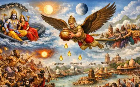
The foundational act in the preservation of India's sacred geography was the establishment of the four great Kumbh sites: Prayagraj at the confluence of the Ganga, Yamuna, and the invisible Saraswati; Haridwar where the Ganga enters the plains; Ujjain on the Shipra; and Nashik on the Godavari. These are not random locations. They represent a carefully chosen sacred compass, anchoring the north, the center, the west, and the south. The Kumbh does not stay in one place; it rotates among them according to a precise astrological clock. This rotation was a stroke of geo-spiritual genius. It meant that every few years, the full, immense spiritual energy of the Kumbh was activated at a different corner of the subcontinent, drawing pilgrims from every direction and, in doing so, constantly renewing the sanctity and the memory of these locations. A pilgrim who traveled to the Kumbh at Haridwar would hear the call of Prayagraj and Ujjain, creating a mental map of a single, unified holy land.
This rotating sacred circuit ensured that no single site could ever become the exclusive, dominant center, and that the distant south, linked by the Godavari at Nashik, was an integral part of the sacred whole. The Godavari was deliberately linked to the Ganga, becoming the "Dakshin Ganga," and ensuring that the holy geography was not confined to the northern plains. The physical journey of millions of pilgrims, walking and later riding across the vast distances between these four sites, was the act that made the sacred map real. Every step was a line drawn on the earth, a line that connected the Himalayas to the Deccan, the western ghats to the Gangetic plain. The Kumbh preserved sacred geography by making it a lived, physical, and cyclical reality, an inheritance walked by countless generations.
The Life-Giving Routes: Pilgrimage Paths as Arteries of Memory 🚶
The four sacred sites were the nodes, but the pilgrimage routes connecting them were the living arteries that circulated the memory of the holy land. For centuries, millions of pilgrims did not fly or take a train; they walked, often for months, in massive, self-organized caravans called kafilas. These routes, lined with dharamshalas, stepwells, and temples built by generations of pious donors, became permanent features of the landscape. They were the physical infrastructure of sacred memory. The journey itself was an immersive education in the geography of faith. A pilgrim from a Tamil village, walking to the Godavari for the Nashik Kumbh, would pass through a dozen sacred sites, hear local legends, and learn the names of holy rivers and mountains, stitching them into a single, coherent, and deeply personal map of the divine land.
These pilgrimage routes preserved the sacred geography by embedding it in the very fabric of the land. The old pathways, the ancient fords, the stone rest houses—these were not just functional; they were mnemonic devices. They whispered to every traveler, "You are on the path to the Sangam. You are walking where your ancestors walked." The routes also became channels for economic and cultural exchange, ensuring the villages and towns along them had a vested interest in preserving the stories and the sanctity of the path. The Kumbh, as the ultimate destination, was the gravitational force that created and maintained this vast, distributed network of sacred pathways, ensuring that the map of holy India was not a fragile document in a library but a robust, well-trodden reality on the ground.
Trending Guides Now

History of Ardh Kumbh Mela From Samudra Manthan to Modern Times
Read Guide →
How Saints and Sadhus Define the Ardh Kumbh Tradition
Read Guide →
Why Saints Are Called Living Archives of Kumbh
Read Guide →
Kumbh vs Ardh Kumbh: The Difference Explained
Read Guide →
Best Routes to Reach Haridwar for Ardh Kumbh Mela
Read Guide →
Ardh Kumbh 2027 Dates (Official) - Haridwar Snan Schedule
Read Guide →
Why Ardh Kumbh Feels Transformational to Pilgrims
Read Guide →
Can Women Fully Participate in All Kumbh Rituals
Read Guide →The Riverine Grid: Preserving the Sanctity of Water Itself 🌊
At the heart of the Kumbh's sacred geography are the rivers themselves—the Ganga, Yamuna, Shipra, and Godavari—living goddesses whose sanctity the Kumbh has preserved and amplified for millennia. The Kumbh is not just about bathing; it is about bathing at a specific, astrologically charged moment in a specific, mythologically potent river. This intense, recurring focus on the rivers as divine beings ensured their worship and protection were woven into the cultural DNA of the subcontinent. The Ganga's descent from the Himalayas, Shiva catching her in his matted locks at Haridwar, the Shipra's association with Mahakal at Ujjain, the Godavari's link to the sage Gautama and the Ramayana at Nashik—these powerful narratives were constantly retold and re-enacted at each Kumbh, making the rivers not just water sources but central characters in a living cosmic drama.
The sacred geography preserved through Kumbh is, at its core, a sacred hydrography. The confluences, the Sangams, are the most potent points on this map. The Triveni Sangam at Prayagraj, where the brown Ganga meets the green Yamuna and the invisible Saraswati, is the supreme example. The Kumbh's ritual focus on this exact, precise point of meeting ensured that its spiritual significance was never lost. Every pilgrim who bathes there, who offers water to the sun, is participating in a ritual that reaffirms the sanctity of that specific location. The geography is not just remembered; it is worshipped, and through that worship, it is made eternal. The rivers, which flow regardless of empires and politics, are the ultimate guarantee that this sacred geography cannot be conquered or erased, only honored and preserved.
The Pandas and the Vahis: Personalizing the Sacred Map 📜
The grand, cosmic geography of the four sites and the sacred rivers was made intimately personal by the institution of the pandas, the hereditary pilgrim priests, and their genealogical registers, the vahis. A family from a remote village in Karnataka would have a specific panda at Prayagraj, whose family had served their family for ten or fifteen generations. The panda's vahi recorded the names of their ancestors who had visited the Sangam in 1750, 1820, and 1910. This created a permanent, documented, and deeply emotional link between a specific family lineage and a specific point on the sacred map. The geography was no longer an abstract concept; it was part of their family story, their inherited identity.
This panda-vahi system is one of the most brilliant mechanisms ever devised for the preservation of sacred geography. It is a decentralized, distributed database, with thousands of independent panda families each holding a unique fragment of the collective memory. There is no central archive to burn, no master map to lose. The record of a family's connection to the Sangam is held in a single, handwritten volume, passed from father to son, and brought out for the pilgrim to see at every Kumbh. When a pilgrim sees the name of their great-great-grandfather in that book, the sacred geography of Prayagraj ceases to be a place on a map. It becomes home. This personalized, emotional, and genealogical connection is what has ensured that millions of families would walk across the subcontinent, generation after generation, to return to the same sacred spot, keeping the geography alive in the most powerful way possible.
The Oral Atlas: Stories That Map the Land 🗣️
Before there were maps on paper, there were maps in stories. The sacred geography of India is a landscape saturated with narrative, and the Kumbh has been the great, periodic festival of this storytelling. Every ghat, every temple, every peculiar rock or bend in the river has a story attached to it—a story from the Puranas, the Ramayana, the Mahabharata, or the local folk tradition. These oral traditions are a form of geographic information system. The story of King Bhagiratha's penance, which brought the Ganga to earth and created the sacred landscape of Haridwar, is not just a myth; it is a set of precise spiritual coordinates. It tells the pilgrim what happened here, why it is holy, and how to approach it. The story of the Samudra Manthan, where drops of amrit fell at the four Kumbh sites, is the foundational narrative that unites the entire sacred map.
The Kumbh is the place where these stories are told and retold, by grandmothers to wide-eyed children, by sadhus to gathered pilgrims, by folk singers and theater troupes. The sacred geography is preserved because it is embedded in compelling, memorable, and emotionally resonant narratives. You may forget a list of place names, but you will never forget the story of a grieving king whose penance brought a celestial river to earth. The landscape itself becomes a mnemonic device. When you stand at Har Ki Pauri and see the Ganga rushing through the mountains, the story of Bhagiratha is not just a tale; it is the living, flowing reality before your eyes. The Kumbh ensures that these stories are never forgotten, and by preserving the stories, it preserves the sacred geography they describe.
The Ritual Choreography: Performing the Sacred Map 🛕
The sacred geography of the Kumbh is not just a place to be visited; it is a script to be performed. The elaborate ritual choreography of the Mela is itself a powerful act of geographic preservation. The shahi snan processions, where the akharas march in a strict, hierarchical order to the exact point of the sacred confluence, are a living, moving map. The route they take, the ghats they visit, the precise spot where they enter the water—all of these are part of an ancient, unchanging ritual script that has been passed down through the oral and embodied traditions of the monastic orders. The geography is encoded in the ritual, and the ritual is performed with absolute fidelity, cycle after cycle.
The same is true of the individual pilgrim's ritual. The specific sequence of actions—the walk to the ghat, the formulation of the sankalpa, the three dips facing a specific direction, the offering of Surya Arghya—is a choreography of place. It is a ritual that maps the relationship between the pilgrim, the river, the sun, and the cosmos. By performing this ritual, the pilgrim is actively engaging with and reaffirming the sacred geography. The Kumbh preserved sacred geography not by writing descriptions of it but by designing a set of physical, sensory, and deeply meaningful actions that must be performed at that exact spot. As long as the rituals are performed, the geography cannot be lost. It is inscribed in the very bodies and movements of the faithful.
The Kumbh's Sacred Map Survives Empires and Erasure 🌐
The genius of the Kumbh's system for preserving sacred geography is its resilience. A temple can be demolished, an idol can be shattered, a library can be burned. But a river flows. A pilgrimage route, walked by millions, cannot be erased. A story carried in the hearts of grandmothers and sadhus cannot be burned. The sacred geography preserved by the Kumbh is not dependent on any single monument, text, or political power. It is stored in a distributed network of rivers, routes, genealogical books, oral narratives, and ritual practices. When the great Buddhist universities were sacked, the Kumbh's sacred geography was untouched, because it was not stored in those libraries. When foreign rulers tried to suppress Hindu pilgrimage, the pilgrims still walked, the pandas still kept their records, and the stories were still told in the quiet of the night. The map was in the people, in the water, and in the stars, and no empire could ever fully destroy it.
This decentralized, multi-layered preservation system is the Kumbh's great gift to civilization. It is a model of how to keep a sacred landscape alive, not through centralized, state-sanctioned heritage boards, but through the living, breathing, and walking faith of millions of ordinary people. The Kumbh teaches that the most powerful map of a holy land is not one that hangs on a wall. It is the map that lives in the feet of pilgrims, in the voices of storytellers, in the pages of a panda's vahi, and in the eternal, purifying flow of the sacred rivers themselves.
The Eternal Map That Lives in the Heart
When the tents are folded and the crowds disperse, the sacred geography of the Kumbh does not vanish. It lives on, a luminous, silent map imprinted on the soul of a civilization. The pilgrim returns to their village, but they carry the Sangam within them. They remember the cold water, the chanting, the vast, peaceful crowd. And they will tell their children, and their children will feel the pull of the river. The Kumbh is the great, recurring heartbeat of this sacred landscape, the pulse that ensures the geography of grace is never forgotten. It is a map that is not drawn on paper but woven into the very fabric of human existence, a map that connects the Himalayas to the southern seas, the distant past to the eternal present, and the individual soul to the vast, shimmering body of the divine. The Kumbh has preserved this map, and as long as the planets move and the rivers flow, it will continue to do so, an eternal, living testament to a land that has always known that the ground beneath its feet is holy.
Frequently Asked Questions